The Bourchier and Bowker Pages
Discovering the ancestry of the South African Bowkers, and the English Bourchiers


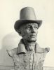
(8) Miles Bowker
Loading...
Ordnance Survey Map of the Deckham Settlement (1895)
Picture Note: Map showing the early settlement on Old Durham Road in Deckham in 1895. The original settlement is bounded in red. Deckham Hall, the original Plough Inn (‘Speed the Plough’) and a small number of domestic property is evidenced.
Media Date: 1895
Keywords: Map
| File name | Ordnance_Survey_Map_of_the_Deckham_Settlement_(1895).JPG |
| File Size | 143.4k |
| Dimensions | 703 x 473 |
| Linked to | (8) Miles Bowker (Birth) |